 |
|
 01-24-2013, 05:35 AM
|
#1
|
|
Member
Winnebago Owners Club Ford Super Duty Owner
Join Date: Sep 2012
Location: Sandusky, Ohio
Posts: 67
|
Driving Pacific Coast highway-La to Wash.
Have a 35' class a with toad. Is it possible or reasonable to drive PCH 1 from north of LA to Washington state. Some say take 101 and use toad to explore. Will be doing this in March. Thanks for help
__________________
Jack Haas
2007 WINNEBAGO VECTRA
JEEP WRANGLER UNLIMITED
|

|

|
 |
Join the #1 RV Forum Today - It's Totally Free!
iRV2.com RV Community - Are you about to start a new improvement on your RV or need some help with some maintenance? Do you need advice on what products to buy? Or maybe you can give others some advice? No matter where you fit in you'll find that iRV2 is a great community to join. Best of all it's totally FREE!
You are currently viewing our boards as a guest so you have limited access to our community. Please take the time to register and you will gain a lot of great new features including; the ability to participate in discussions, network with other RV owners, see fewer ads, upload photographs, create an RV blog, send private messages and so much, much more!
|
|
01-24-2013, 05:53 AM
|
#2
|
|
Senior Member
Join Date: Dec 2012
Posts: 257
|
I am curious too. "Heard" there were some areas with hair pin curves, shear walls on one side of narrow roads with cliffs on the other.
|
|
|
|
|
01-24-2013, 06:50 AM
|
#3
|
|
Senior Member
Join Date: Dec 2012
Location: Full Timing
Posts: 751
|
You will run into some very tight areas north of San Luis Obispo through Big Sur. Beautiful scenery but doesn't sound like a good idea to me for a Class A with a toad.
I've gone through that stretch many times, but on a motorcycle.
__________________
Mike
2003 Alpine Coach 40MDTS - 400HP Cummins ISL
Can Am Spyder Roadster
|
|
|
|
|
01-24-2013, 07:11 AM
|
#4
|
|
Senior Member
Workhorse Chassis Owner
Join Date: Jun 2006
Location: Northwestern Montana
Posts: 3,513
|
The weather in March can be tricky along the coast, especially north of San Francisco and all along the Oregon and Washington coasts. Lots of rain possible that time of year. Traffic will be in your favor, as it is not in tourist season.
Its a doable trip, just take your time, enjoy, and be prepared. We have a 32 foot class A, and have made the trip as far as mid Oregon in both directions. South bound, the scenery is a little more spectacular, but a little nerve wracking on the DW who sits in the co-pilots seat. 
__________________
Dieselclacker
|
|
|
|
|
01-24-2013, 07:18 AM
|
#5
|
|
Senior Member
Join Date: Jun 2006
Location: Dallas,OR
Posts: 4,584
|
Since PCH does not go all the way from OCal to WA state you will be driving US101 many many miles. In reality hwy1 is not really advisable for large vehicles on a lot of it. Just too narrow. Especially around Ft Bragg. In that area your best bet is to park somewhere on 101 and take the toad over to explore 1
__________________
Don and Lorri
Resident Dummy. 
|
|
|
|
|
01-24-2013, 07:27 AM
|
#6
|
|
Senior Member
Join Date: Apr 2012
Posts: 1,526
|
Did that trip twice. Once in a 40' DP with toad in late March/Early Apr 08.
Went from San Diego to Redmond on I5 before taking 299 to 101. Had Driven Hwy 1 north from LA in a car before and decided to avoid that route with my big rig but it has great scenery. 299 had some challenging but not difficult sections.
Absolutly no problen with 101 north of 299 with the 40' + toad. Total lenght 60'. Went all the way to Port Angeles and took a ferry to Victoria. Wonderful trip and we actually saw the sun for several days.
|
|
|
|
|
01-24-2013, 10:19 AM
|
#7
|
|
Senior Member
Join Date: Jul 2012
Posts: 440
|
Having driven Hwy 1 many times from Morro Bay through to Crescent City I can honestly say I wouldn't do it in my 37' MH. There are sections between Santa Cruz and San Francisco that are very narrow and seemingly on the edge of a sheer cliff as said. From there Hwy 1 takes you through SF and over the Golden Gate to the north side, that may be a challenge for some as well as it's quite hectic and full of traffic. North of SF Hwy 1 picks up again from Mill Valley on and is very challenging with extreme hairpin turns that i've seen cars have issues with! If the fog is out it's gonna be triple white knuckle time! South of Benbow Hwy 1 rejoins US101 until Eureka where it once again follows the coast to Oregon.
Not trying to rain on your parade, just making you aware is all. IF it was me i'd probably do US101 and toad to Hwy 1 for trips. I would also avoid SF if possible by taking 101 to San Jose and taking 680 around the bay area traffic to San Rafael, but that's just me. Having been here for years I know what a mess this area can be on traffic.
__________________
2020 Northwood Nash 23D
2020 RAM 2500 Limited Cummins TD
2006 38' Damon Astoria DP 3595 Pacific Edition
|
|
|
|
|
01-24-2013, 10:43 AM
|
#8
|
|
Senior Member
Join Date: Feb 2012
Posts: 273
|
DW and I drove PCH south from Monterey in a 38 ft DP towing an enclosed trailer. I've heard the scenery was beautiful, but can't say, as my eyes were glued to the road. Since we were southbound, DW felt like she was hanging over the many cliffs along the road. The tour buses seemed more inclined to push us further toward the edge, than risking a scratch on their bus.
IMO take US101, and use your toad to explore,(Hearst Castle, Big Sur, Carmel, Monterey, Santa Cruz,etc).
|
|
|
|
|
01-24-2013, 11:04 AM
|
#9
|
|
Senior Member
Foretravel Owners Club
Join Date: Jan 2011
Location: Liberty Lake, WA
Posts: 136
|
The PCH is great fun to drive in a Firebird or any other high performance car. There is not enough money in the world to pay me to drive it in my MH.
__________________
Charlie & Mernie Matthews
2003 Foretravel U320 40
|
|
|
|
|
01-24-2013, 11:16 AM
|
#10
|
|
Senior Member
Join Date: Apr 2012
Posts: 1,526
|
I agree going north on 1 seems safer to me, and I only did that route in a car (northbound) but it is a beautiful part of the country. Stayed at Carmel and played a round at Pebble Beach CG, $$$$, then by Santa Cruz and SF across the GG bridge. As I noted in a previous post, I bypassed that section in my big rig and took I5 to Redmond and 299 to 101 because knew from the prior trip by car of what to avoid with a big rig.
|
|
|
|
|
01-24-2013, 11:19 AM
|
#11
|
|
Senior Member
Country Coach Owners Club
Join Date: Feb 2012
Location: Phoenix AZ
Posts: 240
|
Did Big Sur last summer in our 40' and would not do it again. It's beautiful but at the end of the day you will wonder if it was worth it. Very narrow sections, no gardrails of any consequence and steep cliffs. A Class C is better suited for that section of Cali, IMO.
|
|
|
|
|
01-24-2013, 11:45 AM
|
#12
|
|
Senior Member
Join Date: May 2012
Location: White City, Oregon
Posts: 240
|
Once you get north of San Francisco on 101 you're 'home free' save for the bay area to Cloverdale traffic. Once north of there the only place you really have to pay attention is going through the Redwoods along the Ell River. Beyond that its clear sailing all the way to the Columbia River.
|
|
|
|
|
01-24-2013, 11:57 AM
|
#13
|
|
Member
Winnebago Owners Club Ford Super Duty Owner
Join Date: Sep 2012
Location: Sandusky, Ohio
Posts: 67
|
Thanks to all for your imput. Sounds like 101 and side trips in the toad
Jack
__________________
Jack Haas
2007 WINNEBAGO VECTRA
JEEP WRANGLER UNLIMITED
|
|
|
|
|
01-24-2013, 12:05 PM
|
#14
|
|
Senior Member
Join Date: May 2012
Location: White City, Oregon
Posts: 240
|
Been years since I did the Hwy 1 pit and you only really want to do this by auto.
Mendocino County
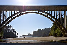 
Highway 1 crosses Russian Gulch State Park on the Frederick W. Panhorst Bridge
Highway 1 then crosses the Gualala River and enters Mendocino County. The highway enters the city of Point Arena, in which it becomes Main Street, before following School Street to the northwest and then becoming Shoreline Highway once again. It bridges the Garcia River and then, near Elk, the Navarro River, where it meets Highway 128.
At the town of Albion, the Albion River is spanned by the Albion River Bridge, the only remaining wooden trestle bridge on the highway. Highway 1 then passes through Little River and Van Damme State Park, crosses Big River and passes through Mendocino Headlands State Park and the Victorian community of Mendocino. Continuing north, Highway 1 crosses Russian Gulch State Park on the Frederick W. Panhorst Bridge, and passes through the town of Caspar. It passes through a roundabout just south of the intersection with the western terminus of State Highway 20, [8][9] where it widens to two lanes, then bridges the Noyo River at Noyo, becomes Main Street of Fort Bragg, and crosses the California Western Railroad.
North of Fort Bragg as a single-lane highway again, Highway 1 passes MacKerricher State Park and the towns of Cleone and Inglenook before crossing Ten Mile River. After passing Westport-Union Landing State Beach, the road goes through a series of redwood-forested switchbacks before reaching Rockport. North of Rockport, the highway turns away from the Lost Coast to avoid steep and unstable highlands created by Mendocino Triple Junction uplift. The highway follows Cottaneva Creek inland through redwood-forested mountainous terrain before terminating at US 101 just outside Leggett.
|
|
|
|
|
|
|
Currently Active Users Viewing This Thread: 1 (0 members and 1 guests)
|
|
|
 Posting Rules
|
You may not post new threads
You may not post replies
You may not post attachments
You may not edit your posts
HTML code is Off
|
|
|
|
 » Recent Discussions
 |
|
|
|
|
|
|
|
|
|
|
|
|
|
|
|
|
|
|
|
|
|
|
|
|
|


 Linear Mode

